|
|
|
|||||||
| We no longer use activation emails. Please allow 24h after sign up and your account should work |
 |
|
|
Thread Tools | Display Modes |
|
#1
 30-08-2014, 11:22 AM
|
||||
|
||||
|
I see they have begun to take away the hill that formed the old staiths crossing point at the end of Leases street.
Now it looks like this is going to be a pedestrian area to me on the plans, but someone tells me no, it's a car-park. the outline of the work area is here and more and the artist's impression here: 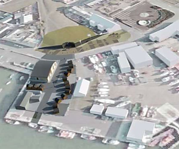 wife's mobile phone photo of that hill today (it's a naff photo but you get the idea) 

|
|
#2
30-08-2014, 01:21 PM
|
||||
|
||||
|
looks like those links die quickly! another search with all the documents (dont know if that link will last either, useless government websites, always a pain!) maybe this link will persist: http://publicaccess.northumberland.g...SED-370372.pdf [oh I give up, sometimes the links work, sometimes not]
|
|
#4
30-08-2014, 11:03 PM
|
|||
|
|||
|
Quote:
|
|
#5
31-08-2014, 06:42 AM
|
||||
|
||||
|
There is a map on here somewhere from around that time. The river would have run along the edge of Leazes St at the time? and therefore this area would have been the point the waggonway reached the river before land reclaiming started in earnest. Looking at the sea level though any remnants would probably be lower down than the present exposed area?
|
|
#6
31-08-2014, 09:20 AM
|
||||
|
||||
|
There was some sort of junction/ points there under that hill but a little further back than they are going to cut away. The wagonway that ran along the high water mark (along Leases street) passes through the site of the 'harbour village', then curves to cross the river and onto the north side.

|
|
#7
31-08-2014, 09:31 AM
|
||||
|
||||
|
Then there's this Admiralty map dated 1848 showing the proposed "Asher Wall" (B) and proposed "New Staith" (C)
Don't know where to start with that one. you can see the Leases street wagonway, and some sort of series of lagoons for land reclamation? 
|
|
#8
31-08-2014, 09:33 AM
|
||||
|
||||
|
I don't get the impression any of that is elevated much above sea level? So perhaps there's some bits and bobs hidden away in the bas of that hill.
Was there not an even earlier wagonway from Hauxley mines that dates back to the 18c along there too?
|
|
#9
31-08-2014, 11:09 AM
|
|||
|
|||
|
Quote:
|
|
#10
31-08-2014, 01:18 PM
|
||||
|
||||
|
Quote:
|
|
#11
25-10-2014, 03:04 PM
|
|||
|
|||
|
Quote:
The foundations had to be reinforced because of the chalk found I took huge lumps to school and got told off by headmaster Hank Johnstone ( never knew his first name ) Geoff Glass
|
|
|
|


 Linear Mode

