|
|
|
|||||||
| We no longer use activation emails. Please allow 24h after sign up and your account should work |
 |
|
|
Thread Tools | Display Modes |
|
|
|
#1
 08-07-2012, 11:16 AM
|
||||
|
||||
|
Looking at some detailed 1753 notes on borings for coal relating to Hauxley Colliery and came across this relating to Wellhaugh point. Looks like there was mining at Wellhaugh, which ties in nicely with my long held suspicion that there is a shaft exposed next to the quarry there. Will add a photo when I get one.
"and for that other coal I mean the coal that was formerly set on at the Well Hugh Rock and has its course thro’ the lower part of Mr Taylors Liberty next the link, this coal is likewise but a low coal, at most but 2 feet three inches and has but a short course from the Well hugh Rock thro’ Mr Taylors liberty into Mr Widdringtons ground where this coal is cut off – Besides this Coal has a very hard stone to sink thro’ and very much water, which will be chargeable at seventy or eighty yards …..to the deep of all the old waste that is as full of water as it can hold." 
|
|
#4
08-12-2012, 07:26 PM
|
||||
|
||||
|
Reading an old geology book (1936) which has some interesting references to seams of coal at Amble:
Amble.—The exposures in the cliffs and on the foreshore for about a mile south of Warkworth Harbour provide the only good sections we have of beds low down in the Coal Measures. Several fossil-bands occur and a few coals, but the exact relationship of these seams to the coals south of the Hauxley Fault is very uncertain. Most of the sequence would appear to lie below the Bottom Coal of Broomhill. .....The general dip is to the S.E., at angles varying from 3° to 8°. A coal, said to have been found many years ago in sewer cutting at the harbour, was reported to be 12 in. thick. It has been taken arbitrarily as the base of the Middle Coal Group. An 18-in. coal a short distance above is said to have been proved at the Gas Works, and again at the top of an old quarry 150 yards to the south. Nothing can now be seen of these coals or their associated strata. Not far above, however, the rock-section begins on the coast at the south pier beacon. Here are the Pan Rocks, yellowish, bedded sandstones forming a broad outcrop on the foreshore. At least 30 feet thick, they were once extensively quarried for water-filters, being coarse, gritty and pebbly, at least in the lower beds. Towards the top they are flaggy and highly false-bedded, and are covered by 12 to 15 feet of greenish shales.' These have small clay-ironstone concretions towards the base, and….. [snip] ………fault of unknown throw, which can be traced seawards as far as low-water mark. Beyond this a sandstone was once quarried near Link House, and supplied much of the stone for building at Amble. It rests on a coal 2 ft. 3 in. thick (at one time wrought on the foreshore), and the lower parts are highly carbonaceous. Mr. Eckford states that in a small collection at Amble school are Gyracanthus spines, said to have been got near the base of a conglomeratic sandstone, where he himself found a fish-tooth and fragments of spines. The Link House sandstone forms the cliff for some distance southwards, and there are extensive outcrops on the foreshore; the upper beds, which lie in a series of folds, are false-bedded and lenticular, with several bands of shale. At the south end of the exposures a broad domed outcrop of sandstone covers a coal, locally 2 ft. 5 in. thick. This seam would certainly appear to lie under the higher beds of the Link House sandstone; it may even be the seam known at the north end of the cliff at the….
|
|
#7
06-01-2013, 06:03 PM
|
|||
|
|||
|
My nephew has pointed me in the direction of a wonderful postcard for sale on the internet. It is a photograph by Burrows of Amble showing a group of miners (including one down a hole) and onlookers digging for coal by rocky outcrops. Coquet Island is in the background. I guess its Wellhaugh Point or the Rocky Shore, as we called it. The website claims it is dated 1915.
Fortunately I found another site which sold the same card back in 2011 and this also displays the reverse, which was sent by Tom C to Mrs Grisdale of South Shields on 12 March 1910: "...We are still in the midst of the strike here. This completes the tenth week of the stoppage. This card will give you some idea of how the men are getting their coals at present. You can just see the island in the background."
|
|
#8
07-01-2013, 05:21 PM
|
||||
|
||||
|
They must have been using explosives on the beach in 1910; the National Archives holds this document:
http://discovery.nationalarchives.go...s?uri=C6395921 This is the area I believe in blue, lots of rectangular pits, merging into an extensive broken mass. The yellow line is the axis of an anticline fold as mentioned in the geology memoir above. The whole mined area is another anticline but a bit more subtle to detect. There's a line of more circular looking pits along the western edge of that blue square - the could be the shafts mentioned in the geology memoir which have workings under the dunes. It would suggest about 10 metres of erosion in about 80 odd years. 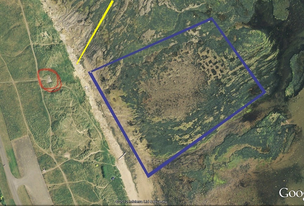 [ © 2012 Google Infoterra Ltd and Bluesky ] Does anyone know what the concrete platform was? (ringed in red above) I thought it must be the isolation hospital (see this map) but it can't be as it's in the wrong position.  .
|
|
#9
07-01-2013, 07:00 PM
|
||||
|
||||
|
Just out of interest, while searching the National Archives catalogue I came across this reference
Elizabeth I - George IV Exchequer: Pipe Office: Particulars, Warrants and Transcripts for Crown Leases Bee, Edward: Lands and tenements in Bywell, Bromley, Mickley, Shotley, Newbiggin, Slaley, Ridinge, and Le Ley; the site of the manor of Amble, a salt-pit in Amble, a coalmine in Amble and Anyley and a tenement in Le Castlegarth in Newcastle. 1618 wow - Is that our earliest reference to mining in Amble? (and perhaps Anyley is Hauxley too?) The challenge now is to get back to 15xx something! then next stop Anglo-Saxon coal mining in Amble! 
|
|
#10
09-01-2013, 11:46 AM
|
|||
|
|||
|
Quote:

|
|
#11
09-01-2013, 11:55 AM
|
|||
|
|||
|
Quote:
|
|
#12
09-01-2013, 03:07 PM
|
||||
|
||||
|
Quote:
Here's the historic 'miners' strike' beach activity playing out again during the 1984 strike [image courtesy Alan J.]:
|
|
#13
12-01-2013, 02:58 PM
|
||||
|
||||
|
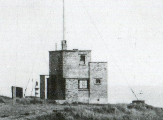
Does anyone know what the concrete platform was? (ringed in red above) I thought it must be the isolation hospital (see this map) but it can't be as it's in the wrong position.
Does this picture help Coquet? the cables look to be on a concrete platform very close to the red ringed area on your photo - perhaps early telegraph? It could be signal cottage? slightly north as well though!
|
|
#14
13-01-2013, 10:43 AM
|
||||
|
||||
|
Quote:
I could be wrong but this is further north, the Rocket Hill or Cliff House - the reason I say this is I think I can see 'Monkey's Island' - as we referred to it as kids - that's the short finger of rock poking out from the right of the frame into the flooded inlet in the mid-ground.
|
|
#16
22-03-2014, 03:32 PM
|
|||
|
|||
|
Quote:
something to do with old caravan site !!!??? toilet block? there was a building near there that was used as a Shop on caravans when they were sited on that side , Bob Coulson ?? (Also delivery van plus shop on Bridge/Queen st, think he also delivered paraffin from van ) , he lived in house first one in alley opposite tescos to george Street behind what is now the Home .had it a grocers, the building was red brick, poss WW2 , that would be late fifties early sixties Last edited by leslie; 22-03-2014 at 03:44 PM.
|
|
#17
22-03-2014, 10:38 PM
|
||||
|
||||
|
Quote:
I'll have to have a look at those artillery site photos - it could have been an observation post for the guns on the cliff? [ the ground in front looking out to sea looks to have been cleared to me]
|
|
#18
23-03-2014, 02:03 PM
|
||||
|
||||
|
As I understand this thread.
The photo above is obviously not the afforementioned area of trenches and explosive use "40 yards north of the salt works". There must have been two major areas of coal excavation below high water mark, the photo above south out by the caravan park and the salt pans area a couple of 100 metres south of the current Quarry wall.
|
|
#19
17-01-2013, 06:07 PM
|
|||
|
|||
|
My wife has studied both map and photo with regard to discussions of Coquet and JanWhin. She remembers a Coastguard lookout station in that area and wonders if the concrete is the remains of that. Also during WW2 she remembers there was a gun emplacement in that area. We would both cede to more detailed info as it is a long time since we lived in the area. Could it even be the base of The Cliff Cafe?
|
|
#20
18-01-2013, 11:18 AM
|
||||
|
||||
|
The gun emplacement was on the highest ground on top of the cliffs on the southern edge of the quarry, but the concrete floor shown above (a hundred or so metres south of the gun site) could be WW2 and something to do with the Wellhaugh guns?
It could be possibly be just the concrete floor Public toilets as they are shown on later maps but I think the position is wrong. On the subject of the Guns at Wellhaugh AKA 'The Amble Battery' I did ask the National Army Museum if they had a picture but the don't have one unfortunately. English Heritage notes on the site
|
|
|
|


 Hybrid Mode
