|
|
|
|||||||
| We no longer use activation emails. Please allow 24h after sign up and your account should work |
 |
|
|
Thread Tools | Display Modes |
|
#21
 20-07-2016, 02:58 PM
|
|||
|
|||
|
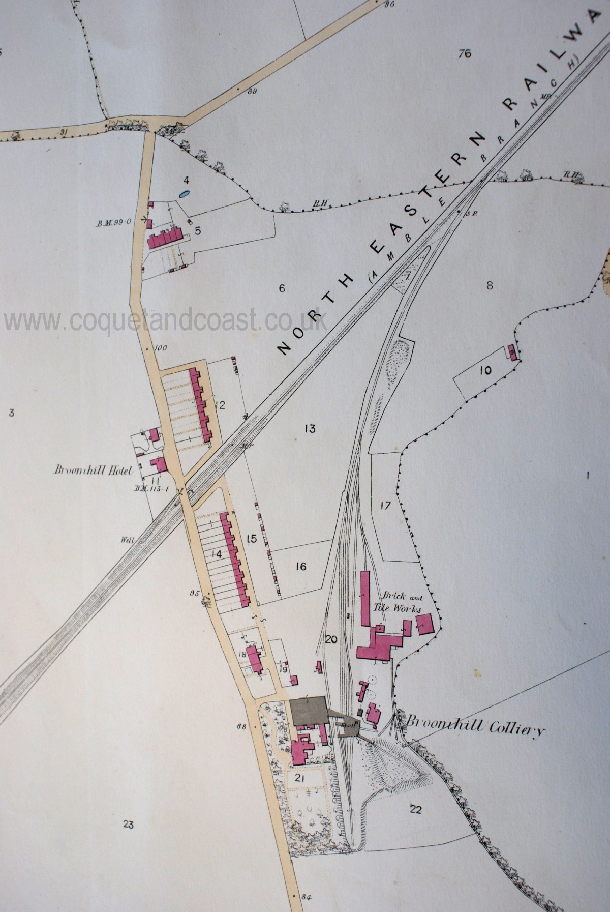
Now the question is, when was Cross Row built at South Broomhill??
In 1921 my dad's family are living in Front Row but I then have a church register entry for March 1923 placing the family at Cross Row. 
|
|
#22
20-07-2016, 03:47 PM
|
||||
|
||||
|
Quote:
Same place I think. Underwent a name change for some reason.
|
|
#24
01-08-2016, 03:30 PM
|
|||
|
|||
|
Quote:
|
|
#25
03-08-2016, 03:23 PM
|
|||
|
|||
|
Quote:
In 1955 I had the 'pleasure' of entering most drifts belonging to Broomhill Colliery, but not that particular one. There would be a spoil heap thereabouts but before my time.
|
|
#26
14-08-2016, 03:42 PM
|
||||
|
||||
|
Quote:
It's odd how this one has avoided inclusion with the ordnance survey. Must have been and gone between editions?
|
|
#27
14-08-2016, 06:42 PM
|
||||
|
||||
|
I did put the larger scale Chevington Drift map on the other site as a series of photo tiles joined together. Not much good but better than nothing until the Library of Scotland get their zoomable versions up.
http://www.fusilier.co.uk/maps_plans...rift-1923.html
|
|
#28
23-08-2016, 01:42 PM
|
|||
|
|||
|
[QUOTE=Coquet;6500]The earlier 1860s map for North Broomhill:
I just had a smile when I re-visited Coquets post. I noted that the 'Thunder Boxes' for Six Cottages seem to have been sited at the south end of the gardens. in 1860. I was born and raised in No 4, 1940 to 1954, and our 'facilities' were built to the north. However, what raised my smile? At the bottom of our garden was a huge rhubarb plant, and I mean huge. Did it have a head start on the rest of the garden? I can only assume that the 'facilities' were moved when Stone Row was extended northward, the road taken out and another inserted along the bottom of Six Cottages gardens. Perhaps a later map could give an answer, and date the extension of Stone Row.
|
|
|
|


 Linear Mode

