|
|
|
|||||||
| We no longer use activation emails. Please allow 24h after sign up and your account should work |
 |
|
|
Thread Tools | Display Modes |
|
#1
 10-09-2012, 05:58 PM
|
||||
|
||||
|
Amble or Warkworth Harbour 1838; with my colouring in, I do like colouring in
 The structure on the riverside, arrowed, what is that? it's actually still there. (or remains of it anyway) I'll get some pictures sometime. Radcliffe colliery railway line in red (the main artery pumping in wealth to the embrioic Amble?) Existing staiths in 1838 are in yellow. Straightened river and proposed harbour developments I've marked in pink. 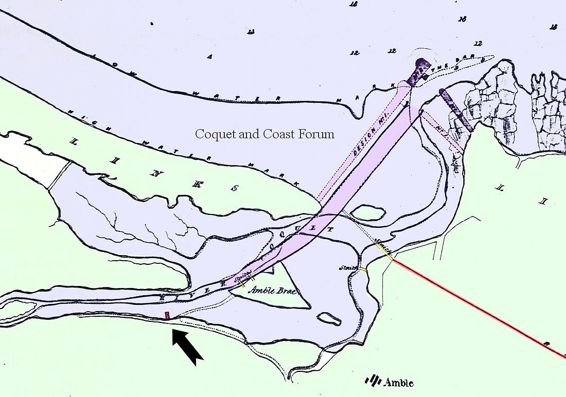

|
|
#2
10-09-2012, 08:28 PM
|
||||
|
||||
|
The structure arrowed, is it the remains of the green wooden boathouse?
It blew down in the summer of 1983, I have an Arthur Young painting of it on the wall next to me now! looking towards Warkworth from early 1983. A little further up river 100m or so, next to the lay by, was a WW11 pillbox demolished in the mid seventies? Last edited by hollydog; 10-09-2012 at 08:30 PM.
|
|
#3
11-09-2012, 08:11 AM
|
||||
|
||||
|
Hi Hollydog, I think its further up the river than the site of the green hut, so the WW2 pill box site might coincide with this earlier building. I wonder if it's the Acklington Foundry Warehouse?
'extensive warehouses, situate on the River Coquet' 'there was at Warkworth a warehouse and shipping place where at spring tides there is water sufficient for vessels drawing from 8 to 9 feet of water.' I cannot remember the pill box, but it would make sense to stick it on top of the remains of this earlier building. If it's the foundry warehouse then it's probably 1780s.
|
|
#4
11-09-2012, 08:21 AM
|
|||
|
|||
|
I think you are right it could have been a warehouse as it is slightly up river from the end of Helsay point and I believe that was where the early ships docked after coming up the "Old Water". If you look at low tide there are the remains of piles along the waters edge in that area, also just off the end of Helsay point there are piles which are set in staight lines as though there had been a pier of some sort there too.
|
|
#5
11-09-2012, 01:19 PM
|
||||
|
||||
|
Here's a photo of it. I'm certain this is the same structure shown in the 1838 map. It's angled upstream slightly, just like on the map. It's a minimum of about 7 metres wide. I think it probably extends under the footpath towards the road.
Not the best picture; I need to take a photo in the morning when the sun's in the right position. There's another large overgrown lump downstream from this that might be the remains of the pill-box mentioned. The Ivy's that thick around that one you can't see anything.  
|
|
|
|


 Linear Mode

