Coquet and Coast Forum
Don't forget to check out our sister site: Amble and District

Go Back   Coquet and Coast Forum > Local History, Genealogy, People and Places > Amble and Hauxley

 We no longer use activation emails. Please allow 24h after sign up and your account should work
Reply
 
Thread Tools Display Modes
  #21  
Old 14-12-2013, 04:20 PM
Coquet's Avatar
Coquet Coquet is offline
Administrator
 
Join Date: Feb 2010
Location: Amble
Posts: 3,253
Default

Quote:
Originally Posted by janwhin View Post
Do you think the "Giant's Cave" became known as that because of the finding of the skeleton? The descriptions of his bones suggest that he was very tall. In fact when did it get the name.....I've always known it as that, so that's at least a hundred years
Didn't think of that. Quite possible there is a connection in the name.
Regarding quarrying on that side; I'll have to have a look to see if there are any traces left - tool marks etc. Never noticed anything before. Of course I always thought it was all natural on that side.
Reply With Quote
  #22  
Old 14-12-2013, 04:52 PM
janwhin janwhin is offline
Senior Member
 
Join Date: Mar 2012
Location: Nr Eglingham
Posts: 1,382
Default

What's been confusing me are the references to the South Pier. It seems that this was the name given to what I know as the breakwater rather than the continuation of the pier, opposite the North Pier

But, there is no South Pier/breakwater on the 1860 map of Amble at Northumberland Communities, only the "pier" or South Jetty.
Reply With Quote
  #23  
Old 14-12-2013, 05:04 PM
Coquet's Avatar
Coquet Coquet is offline
Administrator
 
Join Date: Feb 2010
Location: Amble
Posts: 3,253
Default

Yes it's the concrete and stone breakwater they refer to. The Wooden South Jetty or Pier is a 20th Century addition.

here it is on a card someone has on Flickr:


http://www.flickr.com/photos/4326990...dovews-hGTcMa/


Don't know what date that is but the little east pointing extension to it is under construction I think.
Reply With Quote
  #24  
Old 14-12-2013, 05:07 PM
Coquet's Avatar
Coquet Coquet is offline
Administrator
 
Join Date: Feb 2010
Location: Amble
Posts: 3,253
Default

on that Fickr card there appears to be a building on the extreme left - east of Cliff House, must be perched right on the cliff edge.
Reply With Quote
  #25  
Old 14-12-2013, 06:15 PM
janwhin janwhin is offline
Senior Member
 
Join Date: Mar 2012
Location: Nr Eglingham
Posts: 1,382
Default

Quote:
Originally Posted by Coquet View Post
Yes it's the concrete and stone breakwater they refer to. The Wooden South Jetty or Pier is a 20th Century addition.

here it is on a card someone has on Flickr:

-Don't know what date that is but the little east pointing extension to it is under construction I think.
I believe the south pier/breakwater was rebuilt by about 1905 so I guess that is the date for the card.
Reply With Quote
  #26  
Old 14-12-2013, 06:45 PM
Northern Light Northern Light is offline
Member
 
Join Date: Jan 2013
Posts: 37
Default

Quote:
Originally Posted by Coquet View Post
on that Fickr card there appears to be a building on the extreme left - east of Cliff House, must be perched right on the cliff edge.
Is that not the Salt Pans Coquet
Reply With Quote
  #27  
Old 14-12-2013, 06:59 PM
Northern Light Northern Light is offline
Member
 
Join Date: Jan 2013
Posts: 37
Default

Quote:
Originally Posted by Coquet View Post
Didn't think of that. Quite possible there is a connection in the name.
Regarding quarrying on that side; I'll have to have a look to see if there are any traces left - tool marks etc. Never noticed anything before. Of course I always thought it was all natural on that side.
I think any tool marks etc will have been erroded by now Coquet. However we have noted railway tracks extending down onto the beach in a previous thread. Could this be connected?
Reply With Quote
  #28  
Old 14-12-2013, 07:22 PM
Coquet's Avatar
Coquet Coquet is offline
Administrator
 
Join Date: Feb 2010
Location: Amble
Posts: 3,253
Default

Quote:
Originally Posted by Northern Light View Post
Is that not the Salt Pans Coquet
Yes you're right! I was sitting here thinking it must be part of the coastguard buildings at cliff house. But now you mention it it is the salt pans.
Reply With Quote
  #29  
Old 14-12-2013, 07:30 PM
Coquet's Avatar
Coquet Coquet is offline
Administrator
 
Join Date: Feb 2010
Location: Amble
Posts: 3,253
Default

Quote:
Originally Posted by Northern Light View Post
I think any tool marks etc will have been erroded by now Coquet. However we have noted railway tracks extending down onto the beach in a previous thread. Could this be connected?
Yes we noted a rail track laid around that area.

I can't find that thread again
Reply With Quote
  #30  
Old 14-12-2013, 07:54 PM
Northern Light Northern Light is offline
Member
 
Join Date: Jan 2013
Posts: 37
Default

Quote:
Originally Posted by Coquet View Post
Yes we noted a rail track laid around that area.

I can't find that thread again
There was a link to Township of Amble Plan in the Mystery History Photo thread.
Reply With Quote
  #31  
Old 14-12-2013, 10:34 PM
Coquet's Avatar
Coquet Coquet is offline
Administrator
 
Join Date: Feb 2010
Location: Amble
Posts: 3,253
Default

Quote:
Originally Posted by Northern Light View Post
There was a link to Township of Amble Plan in the Mystery History Photo thread.

got it - it was this map:


http://communities.northumberland.gov.uk/009164FS.htm


I've compared that with Google earth and I'm none the wiser!
Reply With Quote
  #32  
Old 15-12-2013, 09:14 AM
Morph Morph is offline
Member
 
Join Date: Mar 2013
Location: Ellington, Northumberland
Posts: 59
Default

Quote:
Originally Posted by hollydog View Post
It must be refering to the landward end, and quarrying to that north face around the giant's cave makes sense. My only other thoughts were that the area changed totally with the dredging of the harbour and the deepening of the channel for shipping led to the expanse of rocks we see at low tide
Dont forget that the river changed course too, so at some point there would have been dry land at the end of the South Pier.
Reply With Quote
  #33  
Old 15-12-2013, 12:32 PM
leslie leslie is offline
Senior Member
 
Join Date: Jul 2012
Posts: 224
Default

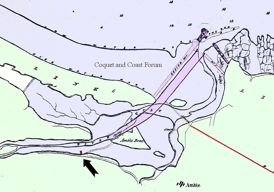
River changed cours 1746 , the 1840 map could be of line cross river to North Pier under construction , natural basin becoming harbour to south as we know it ,, I would think the tracks would be for horse drawn ????? will stand corrected though , on the post card there is visible what looks like a derrick to west of cliff house where quarry would be,
Attached Images
File Type: jpg heritage1 armstrongs map.jpg (26.2 KB, 15 views)
Reply With Quote
  #34  
Old 15-12-2013, 03:25 PM
janwhin janwhin is offline
Senior Member
 
Join Date: Mar 2012
Location: Nr Eglingham
Posts: 1,382
Default

Quote:
Originally Posted by Coquet View Post
got it - it was this map:


http://communities.northumberland.gov.uk/009164FS.htm


I've compared that with Google earth and I'm none the wiser!
This map is oddly aligned, I need to turn sideways to try and work it out. The river seems to be running out to sea below what is now Bay View but they did a heck of a lot of straightening during construction of the harbour.
Reply With Quote
  #35  
Old 15-12-2013, 04:03 PM
Alan J. Alan J. is offline
Senior Member
 
Join Date: Feb 2011
Location: Amble
Posts: 344
Default

Correct jan whin, the river apparently ran along what is now Leezes street, Ladbroke street and out about the Bay view/ little shore area before the harbour was formed. This is in the process of being done on the 1840 map as the North breakwater is underway and you can see wagonways from Amble side over to the North side presumably to transport the stone etc.
Reply With Quote
  #36  
Old 15-12-2013, 05:55 PM
Coquet's Avatar
Coquet Coquet is offline
Administrator
 
Join Date: Feb 2010
Location: Amble
Posts: 3,253
Default

I've laid the old map over google earth map. Tried to line up three points; north pier, radcliffe railway line and cliff house area.

Some interesting things become apparent:

The rail track for the north pier construction stone ran along where Ladbroke/ Newburgh/Leazes street were to be built, with the high water mark right up against it.

Everything north of the rail track was tidal estuary or river channel

Marine Road, Newburgh and Percy Street are laid on the old roads to the links

The first part of Leslie Drive follows and old boundary in Smith's land.

The 'gut' has been moved north (The Archaeological investigation for the proposed Tesco site does state that the land is 'made' (Campbell Smiths land.)

There was a boundary stone at about the junction of Lawson Street and Coquet? Street (corner of the new Town Square)


Base map Copyright Google.

Reply With Quote
  #37  
Old 15-12-2013, 06:01 PM
Coquet's Avatar
Coquet Coquet is offline
Administrator
 
Join Date: Feb 2010
Location: Amble
Posts: 3,253
Default

Runciman Way has a river through the middle of it.
Reply With Quote
  #38  
Old 15-12-2013, 08:31 PM
hollydog's Avatar
hollydog hollydog is offline
Senior Member
 
Join Date: Dec 2011
Location: Amble
Posts: 528
Default

That is a great piece of work! I often wondered how accurate the old map makers were and being able to overlay the points mentioned confirms they had a reasonably good surveying method,
Re: quarrying - Can we assume that the North Pier has stone from the north face of where Cliff House stands? the railway certainly seems to suggest this

Last edited by hollydog; 15-12-2013 at 08:34 PM.
Reply With Quote
  #39  
Old 15-12-2013, 09:35 PM
Alan J. Alan J. is offline
Senior Member
 
Join Date: Feb 2011
Location: Amble
Posts: 344
Default

Right hollydog, according to McAndrews the stone for both piers was procured from the Pan Haven Rocks and afterwards from the quarry near the cliff. A gangway was constructed from the rocks and a small puffing billy, one of the first of it's kind conveyed the stones to the pier. The material for the North pier was taken over the river on a bridge constructed a little above the present brickworks ( now between the Marina and the boatyard ). A few years hence the stones were proved to be ill-suited for such use and had to be replaced using granite from Scotland. It also states that the North pier had always been a cause of concern to the commissioners owing to the force of the North East storms. To add to this there had to be further reinforcement on a fairly major scale in the mid 1980's .
Reply With Quote
  #40  
Old 16-12-2013, 02:16 PM
Coquet's Avatar
Coquet Coquet is offline
Administrator
 
Join Date: Feb 2010
Location: Amble
Posts: 3,253
Default Pre-Harbour map and proposed straightening of the river

I thought we might see something different around cliff house on this 1838 one but the contour looks the same. So there must have been a platform or shelf that was cut away around the current cliffs of Cliff House. In that platform was the bronze age grave - even though the maps are suggesting it is below the high water mark, which seems odd.

Reply With Quote
Reply


Posting Rules
You may not post new threads
You may not post replies
You may not post attachments
You may not edit your posts

BB code is On
Smilies are On
[IMG] code is On
HTML code is Off

Forum Jump


All times are GMT. The time now is 07:23 PM.


Powered by: vBulletin
Copyright ©2000 - 2024, Jelsoft Enterprises Ltd.