|
|
|
|||||||
| We no longer use activation emails. Please allow 24h after sign up and your account should work |
 |
|
|
Thread Tools | Display Modes |
|
#21
 14-03-2016, 04:00 PM
|
|||
|
|||
|
Can I just add a uneducated guess re the road to Warkworth.
If, when Amble was just a small settlement, could the road through not have been straighter, running from Marks Bridge, down Albert Street and across The High Street. That would take the road west of the Manor House, east of where the Gas Works grew up and re-join the road along the river roughly where the entry is for the marina. Other developments later could have necessitated the extension westward of High Street and the two right angle turns in the road as it now is. Just a thought and no doubt historical facts will disprove my lay theory. 
|
|
#22
14-03-2016, 07:03 PM
|
||||
|
||||
|
Now that is interesting. At the top of your red area, the gut has a substantial dressed stone retaining wall, any idea on its age? I always thought it was to do with land reclamation behind, but your map suggests it is on the original river course. How could we date this retaining wall?
Dressed stone, someone spent a lot of time and money building it, wouldn't it be wonderful if it was on a Roman foundation!
|
|
#23
14-03-2016, 07:07 PM
|
||||
|
||||
|
Quote:
Last edited by hollydog; 14-03-2016 at 07:40 PM.
|
|
#24
14-03-2016, 08:43 PM
|
||||
|
||||
|
There must have been something published in the 1820s for the trade directory to be quoting, but no guarantee it will state the precise location even if we found the original record/article.
Here's the 1842 tithe map again for reference. Not that it helps much in finding our ancient road. 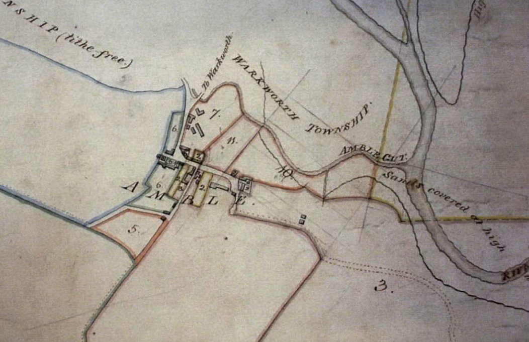
|
|
#26
17-03-2016, 10:45 AM
|
||||
|
||||
|
Quote:
My new pet theory is that the olde road is in there too. Connecting, somehow, up the hillside to olde Amble. Old salt pan lagoons in there somewhere too, with controlled filling on the spring tides.
|
|
#27
17-03-2016, 11:19 AM
|
|||
|
|||
|
McAndrews and the Count History make no mention of an old causeway or building foundations. McAndrews does give a throw away comment about one Northumberland history mentioning the stone foundations of round Anglo Saxon buildings but he dismisses it on the basis that no physical evidence has been found.
When the Manor House was operational and collecting dues there was apparently a jetty where boats moored below the Manor and Hallbank Well. Could this stone wall have anything to do with that?? Before the road between Warkworth and Amble came into being along the river, the old road went up past Gloster Hill and Gilden.
|
|
#28
17-03-2016, 08:12 PM
|
|||
|
|||
|
The land where the proposed Tesco was to have been was all built up with builders rubble and rubbish by Campbell Smith over quite a long period. I was surprised that it was given the go ahead for the Tesco due to the type of stuff that went in there.
|
|
#29
17-03-2016, 09:42 PM
|
||||
|
||||
|
That land is about a hundred yards further east of the wall in the photo. I know what you mean about the rubbish, in the 1940s it was dads saturday job to wheelbarrow the business rubbish; glass, paint etc down there, next to where the foot bridge is now.
|
|
#30
18-03-2016, 06:53 PM
|
||||
|
||||
|
Quote:
|
|
#31
19-03-2016, 08:50 AM
|
||||
|
||||
|
According to "Mackenzie''s History of Northumberland" a Mr John Shanks while forming an embankment discovered an ancient causeway one foot below the surface about two and a half feet wide, strongly paved and running in a straight line from Amble to the old bed of the Coquet, possibly Roman origin. He also refers to a village leaving circular foundation marks, and some monastic ruins.
A 7th C publication of the "Ravenna Commography" also refers to Roman camps at Aluana (Alnmouth) and Cocuenda - presumably mouth of the Coquet (Mcinnes 1880) Credit to J M Hobrough for the above.
|
|
#32
19-03-2016, 10:04 AM
|
||||
|
||||
|
Shanks was also in the salt business. The land in question probably extended down to the gut behind the Queen's Head. Probably the area in your photos. (I think '2.5 feet' in Mackenzie must be an error?) I would not be surprised if the circular stone work were more salt making pans. Here are some circular Elizabethan specimens in Cumbria. http://www.visitcumbria.com/wc/crosscanonby-saltpans/
|
|
#33
19-03-2016, 11:24 AM
|
||||
|
||||
|
Perhaps the speculative Roman settlement was at Amble rather than Gloster Hill. I think Gloster hill was investigated but nothing more that the altar fragment was found. The Romans we the masters of the paved road, and roman coins were found at the bottom of the Wynd in a works trench.
British Roman trunk roads were an average 23' or 7 metres wide. I think Amble must have been an important Roman Port at one time. - just kidding!
|
|
#35
19-03-2016, 03:54 PM
|
||||
|
||||
|
Quote:
http://www.fusilier.co.uk/amble_nort...oster_hill.htm I've just realised, in the note after, Hodgson is referring to a Roman road to Chester house, not the existing road, which is interesting, as the road I am sure is visible on Google Earth. I've mentioned that before- and before I was aware of meaning of Hodgson's note.
|
|
#37
19-03-2016, 06:07 PM
|
||||
|
||||
|
Quote:
I assumed the causeway path would be from Gloster Hill down to the river bank roughly in the direction of the wall discussed earlier. Perhaps discovered when the coop gardens were begun?
|
|
#38
19-03-2016, 06:48 PM
|
||||
|
||||
|
There is something across the field next to Gloster hill farm, visible on Google Earth, a change in the crop pattern, it is straight, position in blue below. Might be nothing of significance. I've also drawn a straight line to Chester House just for interest. The alleged location of the Altar stone is on there, some distance from the straight line to Chester house, but actually on the extrapolated blue line.
The blue line east would pass through Mariner's Court. 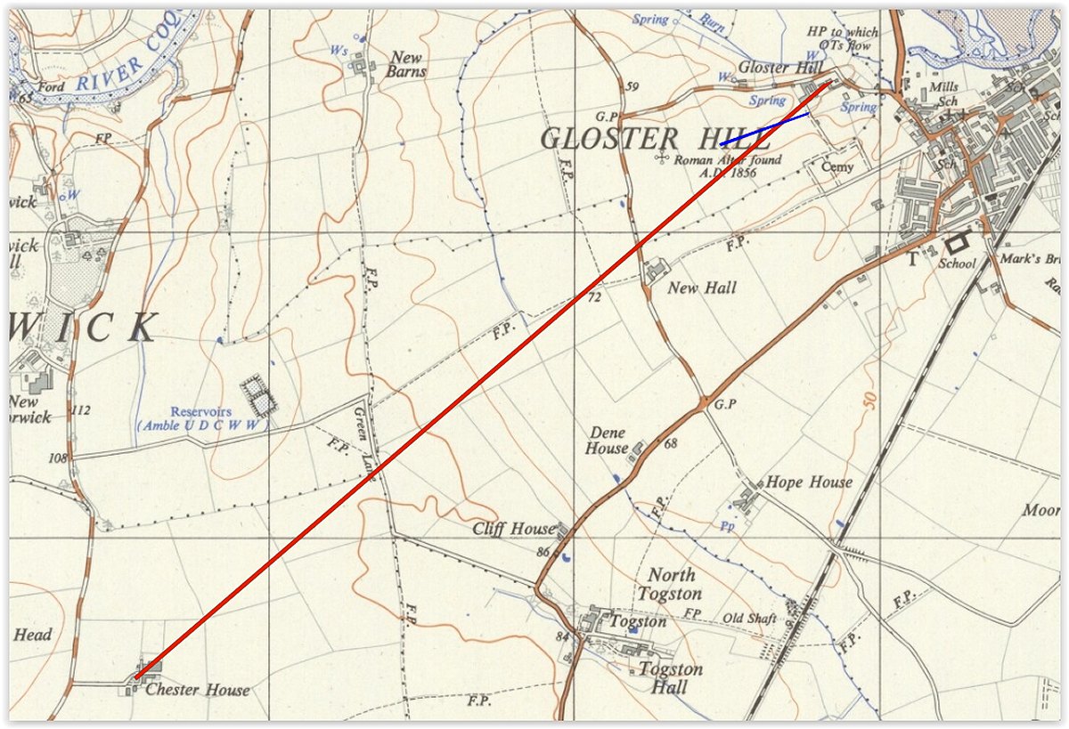
|
|
#39
19-03-2016, 07:46 PM
|
||||
|
||||
|
Ah That blue line is close the route of a water main from Morwick. Back in another era in the early eighties I had a summer job helping farm those fields for Ian Forsyth.I remember a leaking pipe close to that line and various contractors trying to locate the leak.
I do know of a detectorist who found roman coins in that area as well. Ian gave me permission to detect but there is literally only a two day window in those fields between harvest and ploughing / new crop going in, v frustrating.
|
|
|
|


 Linear Mode

