|
|
|
|||||||
| We no longer use activation emails. Please allow 24h after sign up and your account should work |
 |
|
|
Thread Tools | Display Modes |
|
#21
 11-01-2013, 08:19 PM
|
|||
|
|||
|
Quote:

|
|
#22
12-01-2013, 02:58 PM
|
||||
|
||||
|
Does anyone know what the concrete platform was? (ringed in red above) I thought it must be the isolation hospital (see this map) but it can't be as it's in the wrong position.
 Does this picture help Coquet? the cables look to be on a concrete platform very close to the red ringed area on your photo - perhaps early telegraph? It could be signal cottage? slightly north as well though!
|
|
#23
13-01-2013, 10:34 AM
|
||||
|
||||
|
Quote:
|
|
#24
13-01-2013, 10:43 AM
|
||||
|
||||
|
Quote:
I could be wrong but this is further north, the Rocket Hill or Cliff House - the reason I say this is I think I can see 'Monkey's Island'  - as we referred to it as kids - that's the short finger of rock poking out from the right of the frame into the flooded inlet in the mid-ground. - as we referred to it as kids - that's the short finger of rock poking out from the right of the frame into the flooded inlet in the mid-ground.
|
|
#26
13-01-2013, 12:42 PM
|
||||
|
||||
|
There's anchor cables to the mast on the rocket hill as well:
http://www.fusilier.co.uk/old_photos...wall_amble.htm
|
|
#27
16-01-2013, 04:35 PM
|
||||
|
||||
|
I was looking through the newspaper archives for the 'Kicking Cuddy' fire in High Street / Eastgarth Avenue mentioned in this thread
Didn't find it but came across this which relates to this thread regarding miners storing explosives in the home. (which were also being used on the beach a few years earlier - see above) The Journal 15th May 1914. THE AMBLE EXPLOSION. RESULT OF THE INQUEST AT NEWCASTLE INFIRMARY. At Newcastle Infirmary, last night, Mr Alfred Appleby, City Coroner, resumed the inquest on Catherine Turnbull, 44, widow of a miner of Henderson Street, Amble, who died in the institution on May 8 from burns received through a tin of gunpowder exploding at her home. William Broughton Shepherd, a miner at Radcliffe Colliery, belonging to the Broomhill Collieries Ltd, said that he lodged with the deceased until the accident occurred. He had worked at the colliery for about six years. It was the practice in the district for miners to buy their own gunpowder and make up their cartridges at home. On April 30, when leaving for the pit, he asked Mrs Turnbull to get him some powder. The same night he was informed the woman had been burned through the powder exploding but he did not know how the accident occurred. Sergeant Smailes of the Northumberland County Constabulary, stationed in Amble, said that on April 30 he was called to the scene of the accident, and found the woman badly burned about the face, neck and arms. Two doors, four windows, the ceiling in three of the rooms and the furniture were damaged by the explosion. Mrs Turnbull said she was removing a tin of powder from a table in the kitchen to a place in the front room, where it would be safer, when a spark from the fire caused the tin of powder to explode. A verdict of ‘Accidental death’ was returned, the jury expressing the opinion that the keeping of powder in house was a dangerous practice, and hoped it would be stopped.
|
|
#28
17-01-2013, 06:07 PM
|
|||
|
|||
|
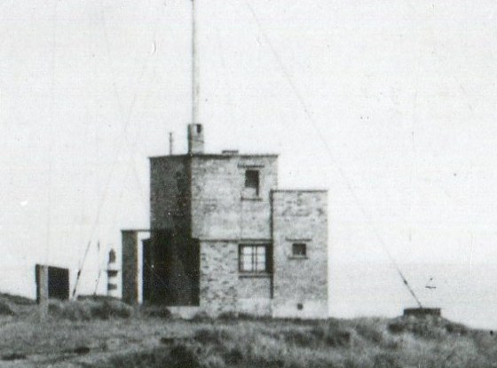
My wife has studied both map and photo with regard to discussions of Coquet and JanWhin. She remembers a Coastguard lookout station in that area and wonders if the concrete is the remains of that. Also during WW2 she remembers there was a gun emplacement in that area. We would both cede to more detailed info as it is a long time since we lived in the area. Could it even be the base of The Cliff Cafe?
|
|
#29
18-01-2013, 11:18 AM
|
||||
|
||||
|
The gun emplacement was on the highest ground on top of the cliffs on the southern edge of the quarry, but the concrete floor shown above (a hundred or so metres south of the gun site) could be WW2 and something to do with the Wellhaugh guns?
It could be possibly be just the concrete floor Public toilets as they are shown on later maps but I think the position is wrong. On the subject of the Guns at Wellhaugh AKA 'The Amble Battery' I did ask the National Army Museum if they had a picture but the don't have one unfortunately. English Heritage notes on the site
|
|
#30
21-03-2014, 11:06 PM
|
||||
|
||||
|
Letter from the Woods Office to the Board of trade Harbour Department. 1878 [unfortunately the map referred to is not present with these documents]
Darlington March 9th 1878 Dear Sir, Warkworth parish. Northumberland. Amble Foreshore encroachment Agreeably with your instructions I yesterday visited Amble, and on the 6 inch Ordnance Map herewith transmitted, have marked in red the site of excavation made by the pitmen in removing the rock for the working of coal underneath. The tide recedes to about where the rocks are marked, and flows quite up to the foot of the bank where the 'Saltworks' stand, and which are at an elevation above the shore adjoining. The Coast Guard people state that at certain times when the wind drives the flood on to this bank, a thin seam of coal is covered up by several feet of blown sand. This seam of about 12 inches to 15 inches in thickness runs under the rock at a depth of about four feet and during the month of January last pitmen out of employ excavated and blasted the rock to get fuel for their own use but not for sale. Commencing at a point about 40 yards north of the saltworks they excavated a trench of about 100 yards in length and one to two yards in width in a straight line to the sea. The water flowed over it each tide and in the course of a short time silted up the trench and nothing is now seen of the excavation but some 'debris' of the rock. the hole being entirely filled up with sand by the flow of the tide. The cause of the working seems to have arisen out of the trade dispute of the Northumberland pitmen who were out on strike for several weeks and consequently did not get their accustomed supply of coals from the pits. - The Radcliffe Colliery, a mile to the south of this working has been in working 40 years and the existence of this outcrop probably would be known to the pitmen. With the return to their usual employ as is now the case the working of the encroachments has ceased and will not likely occur again unless under similar circumstances. I am dear sir, yours faithfully W. Minter.
|
|
#31
21-03-2014, 11:23 PM
|
||||
|
||||
|
It does happen again of course.
1910 letter from Blyth Customs to the Board of Trade: The Collector, Blyth Sir, Encroachments on the foreshore at Amble In accordance with pars. 275/777 Miscellaneous Code I beg to report that encroachments on the foreshore below high water mark close to the Coastguard Signal Station near Amble are now being carried on on a somewhat extensive scale. A large number of miners now out on strike at Amble have commenced blasting for coal on the sea shore where seams are apparent. I understand a 3 feet seam has been discovered and that from forty to fifty tons per day are being got out and sold. Canvassers are going about in Amble endevouring to effect sales. The Chief Officer of Coastguard informs me that he has reported the matter to the Board of Trade. Respectfully R.J. Burgess, Supt. [their underlining] There is a note from the Board of Trade after this saying they should refer the matter to the Woods Office, but the author also states " unless they send an armed force I doubt they will be able to do much" 
|
|
#32
21-03-2014, 11:40 PM
|
||||
|
||||
|
I get the impression now that perhaps a couple of shallow seams of coal pass under Amble and have been worked in various places including Wellhaugh and into the town area as per the discussion regarding the Percy Street pumps on here, and these beach workings are possibly in the same seams. These seams are also in close proximity an aquifer that possibly cuts across the town from Gloster hill, via Hallbank well and Percy Street and on to the shore.
Wellhaugh is allegedly named such because of the well there - this is now supposed to be on the foreshore- it is there - it's either a well or an ancient coal shaft that's gone artisian. So perhaps that is the eastern extremity of the accessible part of it.
|
|
#33
22-03-2014, 03:32 PM
|
|||
|
|||
|
Quote:
something to do with old caravan site !!!??? toilet block? there was a building near there that was used as a Shop on caravans when they were sited on that side , Bob Coulson ?? (Also delivery van plus shop on Bridge/Queen st, think he also delivered paraffin from van ) , he lived in house first one in alley opposite tescos to george Street behind what is now the Home .had it a grocers, the building was red brick, poss WW2 , that would be late fifties early sixties Last edited by leslie; 22-03-2014 at 03:44 PM.
|
|
#34
22-03-2014, 10:38 PM
|
||||
|
||||
|
Quote:
I'll have to have a look at those artillery site photos - it could have been an observation post for the guns on the cliff? [ the ground in front looking out to sea looks to have been cleared to me]
|
|
#35
23-03-2014, 02:03 PM
|
||||
|
||||
|
As I understand this thread.
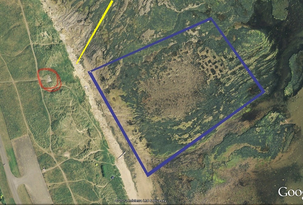
The photo above is obviously not the afforementioned area of trenches and explosive use "40 yards north of the salt works". There must have been two major areas of coal excavation below high water mark, the photo above south out by the caravan park and the salt pans area a couple of 100 metres south of the current Quarry wall.
|
|
#36
23-03-2014, 05:07 PM
|
||||
|
||||
|
Quote:
There are pits and shafts in the blue area as well. When you look at that area "A" today it does look like it's been blown up with explosives 
|
|
#37
27-03-2014, 07:28 PM
|
||||
|
||||
|
Not sure if this photo has been on here as the site is growing so quickly!
Coquet Island is there in the background, this is on ebay at the moment with a price of £125!!! Worth a look as it details the date (1915) and the strike at the time. Strange having a strike during wartime ? is this information correct Coquet? http://cgi.ebay.co.uk/ws/eBayISAPI.d...E:B:SS:GB:1120 Last edited by hollydog; 27-03-2014 at 07:30 PM.
|
|
#39
27-03-2014, 11:06 PM
|
|||
|
|||
|
You get the prize Coquet. My nephew pointed this card out to me a couple of years ago when it was for sale at £50. Fortunately another search revealed the reverse of the card which had a date of 1910.
|
|
#40
13-12-2014, 03:23 PM
|
||||
|
||||
|
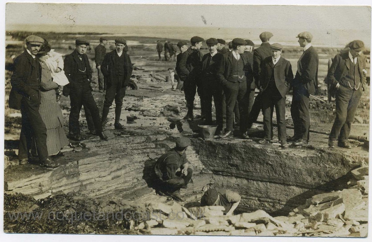
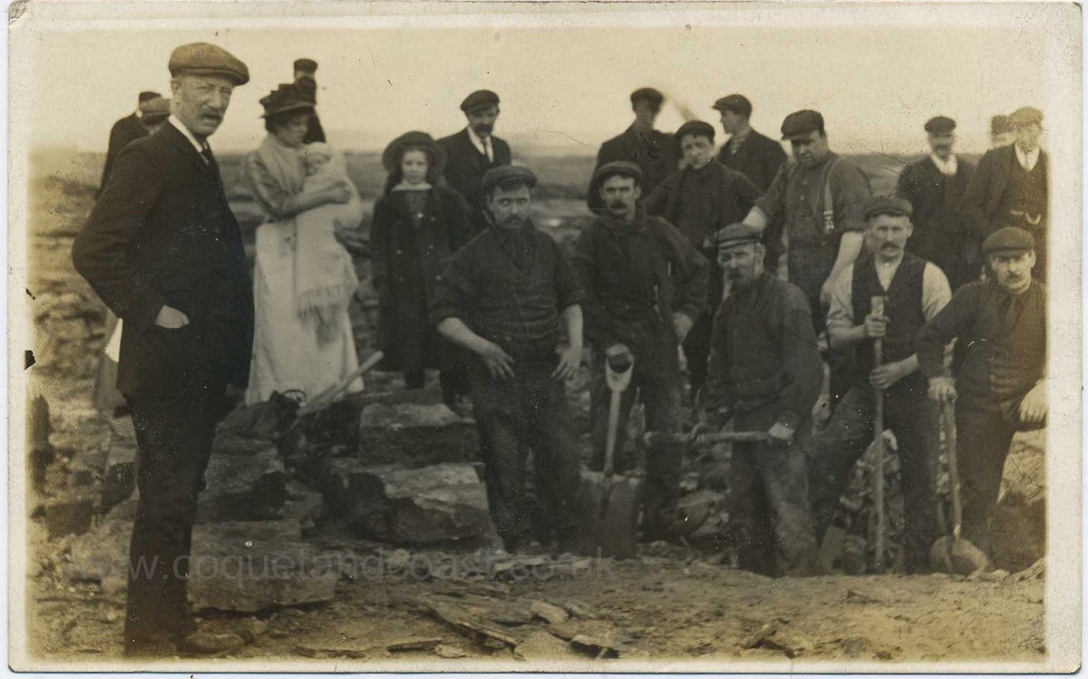
An ebay seller recently disposed of an album of photographs belonging to the Gibson family of the Steamboat Inn and the Gardeners Arms. (Thanks to hollydog for pointing these out) We've been kindly granted permission to add here the scans of two of the cards from the album that relate to Amble 'beach mining' during one of the miners' strikes:
|
|
|
|


 Linear Mode

