|
|
|
|||||||
| We no longer use activation emails. Please allow 24h after sign up and your account should work |
 |
|
|
Thread Tools | Display Modes |
|
|
|
#1
 22-10-2014, 12:18 PM
|
||||
|
||||
|
This is the Hauxley Victoria Seam, N.C.B letter "T", worked north of the Hauxley Fault.
The green are the contours of the surface of the seam in feet from [Ordnance Datum +10000] Years are added in blue. Coal height in black in inches. Faults in red. The last seam worked by deep mining in the Amble parish? 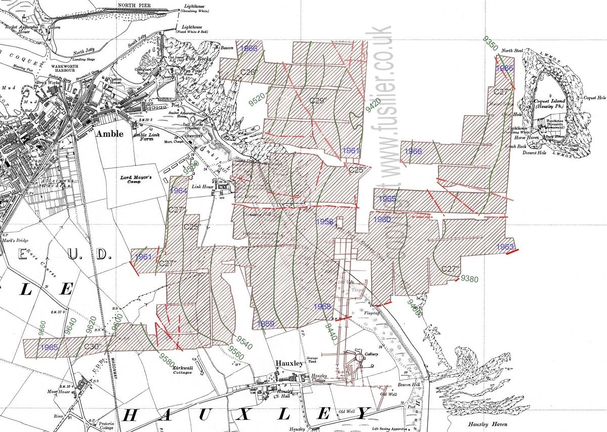 
|
|
#2
22-10-2014, 12:21 PM
|
||||
|
||||
|
There's a small amount of data missing to the northernmost workings as they do extend a little further than shown. If memory serves me correctly, from looking at the Ellington plans, they terminate in front of the harbour mouth.
|
|
#4
22-10-2014, 03:07 PM
|
|||
|
|||
|
The county name is Victoria but at Hauxley the local name was the Brockwell.
The North winnings was the face that ended about half a mile off the pier ends, the face under the Lord Mayors was North West 1 and the one near Moorhouse was West 3. This was the longest walk, to the tailgate end, in the pit at closure.
|
|
#5
22-10-2014, 06:43 PM
|
||||
|
||||
|
Quote:
|
|
#6
23-10-2014, 06:52 AM
|
|||
|
|||
|
Funnily enough it was always talked about at Hauxley that there was another seam, below the Brockwell, called the Victoria. It was supposed to be very similar to the Brockwell and may be a follow up later on.
|
|
#7
14-03-2016, 04:24 PM
|
|||
|
|||
|
I've found two different dates for the year Hauxley colliery closed: 1966 and 1968. Can anyone confirm which is correct?
|
|
#8
14-03-2016, 05:11 PM
|
||||
|
||||
|
Quote:
|
|
#10
14-03-2016, 06:34 PM
|
||||
|
||||
|
I saw the Ambler article, good to see and read, Anna.
I reckon its a mine shaft, is there not three marked around there? although the opencast may have just about taken them in. Still wondering about the famous dip in the road at the farm, I'm amazed the adjacent house has no obvious cracks! A number of vehicles are certainly suffering.
|
|
#11
14-03-2016, 08:03 PM
|
|||
|
|||
|
As stated Hauxley colliery closed on November 26th 1966 for coal production, 3 months were allocated for salvage and the remaining men left February 1967. A lot of the older men took retirement the rest went to their designated spots at Shilbottle and Whittle. The very first ones to leave went as early as January 1966 and the pit went onto production in one shift only, this continued until the closure.
|
|
#12
15-03-2016, 10:53 AM
|
||||
|
||||
|
Quote:
Maps below - Contains British Geological Survey materials © NERC 2016 reproduced under the Open Government Licence I've joined the relevant maps for Hauxley and Amble together, they are: Geological Survey of England and Wales 1:63,360 geological map series [Old Series] Coast from near Coquet Island to Newbiggin, Drift published 1882, (east side of image) and the Rothbury drift sheet, published 1895. One curious omission is the Hauxley fault? It's just not there. They do have the Bondicar fault marked, with a 300' throw. The more modern maps do have more accurate details, but do not mark old pits. Unfortunately cannot reproduce them here. I've had a few shots now at finding the Acklington Dyke on the beach. Failed every time.   sorry if this pic does not fit your screen very well, I've made it 1400 wide to fit mine nicely. 
|
|
#13
15-03-2016, 03:10 PM
|
|||
|
|||
|
Thank you
|
|
#14
15-03-2016, 07:14 PM
|
|||
|
|||
|
More likely to be drainage for new houses, possibly a wet well for a pumping station.
Togston opencast only worked up to Hauxley fault. Area to the North was only used to stockpile overburden so any shafts should still be there. The only shaft that I am aware of being capped while the opencast was working was behind Togston Hall.
|
|
#15
15-03-2016, 09:45 PM
|
||||
|
||||
|
Quote:
Here's the plan if it will open (it will take a while). Looks like there is a sub-station around that area. Funny you should mention pumping stations but I thought I saw one on the plans the other day -I must have been mistaken. https://publicaccess.northumberland....V_C-315916.pdf ..and the coal mining risk assessment: Part 1 Part 2 (blank) Part 3
|
|
|
|


 Hybrid Mode
