Coquet and Coast Forum
Don't forget to check out our sister site: Amble and District

Go Back   Coquet and Coast Forum > Local History, Genealogy, People and Places > Amble and Hauxley

 We no longer use activation emails. Please allow 24h after sign up and your account should work
Reply
 
Thread Tools Display Modes
  #21  
Old 26-02-2016, 01:19 PM
Coquet's Avatar
Coquet Coquet is offline
Administrator
 
Join Date: Feb 2010
Location: Amble
Posts: 3,253
Default

Interesting observation from the mining plans regarding these G seam workings is that the northern parts are actually north of the surface position of the Hauxley fault. So the fault plane dips to the north, allowing them to work under its surface position.
Reply With Quote
  #22  
Old 26-02-2016, 02:19 PM
Coquet's Avatar
Coquet Coquet is offline
Administrator
 
Join Date: Feb 2010
Location: Amble
Posts: 3,253
Default

Another useless fact, if they had gone north through the Hauxley fault and drifted down a mere 100 feet they would've been in the Hauxley Brockwell/Victoria T Seam.
Reply With Quote
  #23  
Old 26-02-2016, 03:52 PM
Coquet's Avatar
Coquet Coquet is offline
Administrator
 
Join Date: Feb 2010
Location: Amble
Posts: 3,253
Default

Quote:
Originally Posted by Alan J. View Post
Interesting to see the Townhead shown, there were two insets in the Shilbottle shafts, Townhead and Cannel Coal. These had been encountered in the sinking but not considered for working.

I've finally got a copy of the Alnwick geology memoir, 1930. It has the details of the Shillbottle Grange shaft strata in it. I've put it in a new thread in the Shilbottle section. The three significant coals are identified ( plus two more??)
Reply With Quote
  #24  
Old 26-02-2016, 07:52 PM
hollydog's Avatar
hollydog hollydog is offline
Senior Member
 
Join Date: Dec 2011
Location: Amble
Posts: 528
Default

Quote:
Originally Posted by Coquet View Post
That would be the Moorhouse Drift into the coal worked by Broomhill I think? Alan J has commented on that one. Also here. I have no recollection of it.


Is that, where FB is marked on the map the WW11 tank trap? and yes, around 1974 it was possible to look into the drift down the steps!
Reply With Quote
  #25  
Old 26-02-2016, 08:20 PM
Coquet's Avatar
Coquet Coquet is offline
Administrator
 
Join Date: Feb 2010
Location: Amble
Posts: 3,253
Default

Quote:
Is that, where FB is marked on the map the WW11 tank trap? and yes, around 1974 it was possible to look into the drift down the steps!
I wondered what that was. FB is normally a footbridge, so that will be logical. Again with that one "I have no recollection" Is the tank trap still there? or have they filled it in?
Reply With Quote
  #26  
Old 26-02-2016, 09:42 PM
hollydog's Avatar
hollydog hollydog is offline
Senior Member
 
Join Date: Dec 2011
Location: Amble
Posts: 528
Default

Quote:
Originally Posted by Coquet View Post
I wondered what that was. FB is normally a footbridge, so that will be logical. Again with that one "I have no recollection" Is the tank trap still there? or have they filled it in?
What remains is on the left heading south after the roundabout before Moorhouse farm I think
Reply With Quote
  #27  
Old 14-03-2016, 12:34 AM
Coquet's Avatar
Coquet Coquet is offline
Administrator
 
Join Date: Feb 2010
Location: Amble
Posts: 3,253
Default

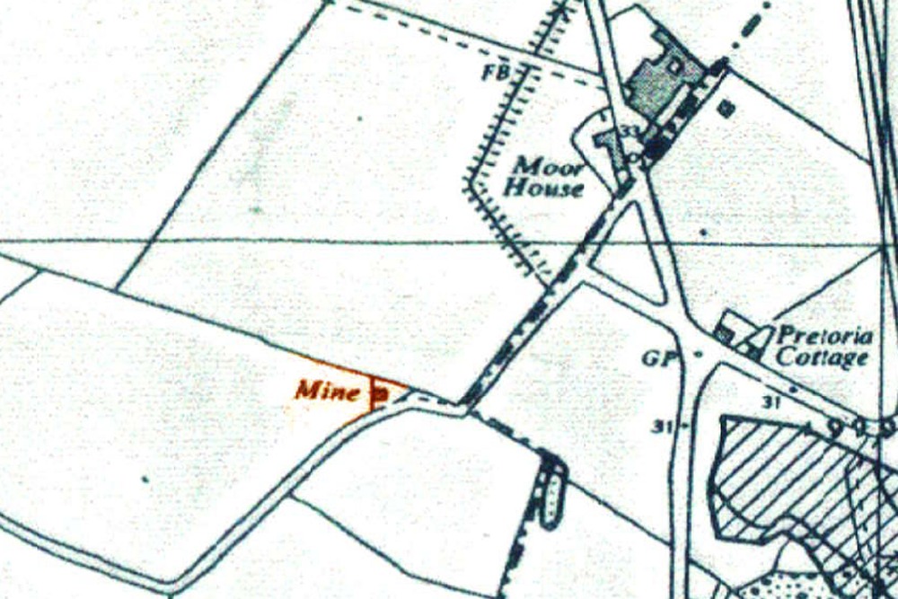
Anyone had a look up at the Mark's Bridge development recently?
looks like they have that old shaft located?

I see in the mining reports (with the documents lodged with Northumberland Council planning applications) that they have to locate the shaft as shown on the Coal Authority map and do the necessary.


It's close to the road where we expected it to be.


Reply With Quote
  #28  
Old 14-03-2016, 07:32 AM
Alan J. Alan J. is offline
Senior Member
 
Join Date: Feb 2011
Location: Amble
Posts: 344
Default

Thought it was to do with drainage, will have to have look up there.
Reply With Quote
  #29  
Old 14-03-2016, 09:10 AM
Coquet's Avatar
Coquet Coquet is offline
Administrator
 
Join Date: Feb 2010
Location: Amble
Posts: 3,253
Default

I thought about that, sewerage/drainage. Might be worth asking in the sale office up there?

I remember reading something in the planning documents regarding the existing sewer for Marks Bridge bungalows; it being 300mm diameter and inadequate for an additional 254(? can't remember the number) houses.
Reply With Quote
  #30  
Old 14-03-2016, 04:24 PM
AnnaAtTheAmbler AnnaAtTheAmbler is offline
New Member
 
Join Date: Jun 2010
Posts: 9
Default Hauxley pit closure date

I've found two different dates for the year Hauxley colliery closed: 1966 and 1968. Can anyone confirm which is correct?
Reply With Quote
  #31  
Old 14-03-2016, 05:11 PM
Coquet's Avatar
Coquet Coquet is offline
Administrator
 
Join Date: Feb 2010
Location: Amble
Posts: 3,253
Default

Quote:
Originally Posted by AnnaAtTheAmbler View Post
I've found two different dates for the year Hauxley colliery closed: 1966 and 1968. Can anyone confirm which is correct?
'Closure' is generally taken as the date production ceased. For Hauxley that was 26th November 1966.
Reply With Quote
  #32  
Old 14-03-2016, 05:17 PM
Coquet's Avatar
Coquet Coquet is offline
Administrator
 
Join Date: Feb 2010
Location: Amble
Posts: 3,253
Default

Oh Yes..Many thanks Anna for the article in the 'Ambler' on these websites.
Reply With Quote
  #33  
Old 14-03-2016, 06:34 PM
hollydog's Avatar
hollydog hollydog is offline
Senior Member
 
Join Date: Dec 2011
Location: Amble
Posts: 528
Default

I saw the Ambler article, good to see and read, Anna.

I reckon its a mine shaft, is there not three marked around there? although the opencast may have just about taken them in.

Still wondering about the famous dip in the road at the farm, I'm amazed the adjacent house has no obvious cracks! A number of vehicles are certainly suffering.
Reply With Quote
  #34  
Old 14-03-2016, 08:03 PM
Alan J. Alan J. is offline
Senior Member
 
Join Date: Feb 2011
Location: Amble
Posts: 344
Default

As stated Hauxley colliery closed on November 26th 1966 for coal production, 3 months were allocated for salvage and the remaining men left February 1967. A lot of the older men took retirement the rest went to their designated spots at Shilbottle and Whittle. The very first ones to leave went as early as January 1966 and the pit went onto production in one shift only, this continued until the closure.
Reply With Quote
  #35  
Old 15-03-2016, 10:53 AM
Coquet's Avatar
Coquet Coquet is offline
Administrator
 
Join Date: Feb 2010
Location: Amble
Posts: 3,253
Default

Quote:
Originally Posted by hollydog View Post

I reckon its a mine shaft, is there not three marked around there? although the opencast may have just about taken them in.
The old Geology maps show 'Pits' plural in the Moorhouse area, but I think the bulk of the shafts are to the south according to the coal authority map, which are outside of the Persimmon site, and now destroyed by open-casting.

Maps below - Contains British Geological Survey materials © NERC 2016
reproduced under the Open Government Licence

I've joined the relevant maps for Hauxley and Amble together, they are:
Geological Survey of England and Wales 1:63,360 geological map series [Old Series] Coast from near Coquet Island to Newbiggin, Drift published 1882, (east side of image) and the Rothbury drift sheet, published 1895.

One curious omission is the Hauxley fault? It's just not there. They do have the Bondicar fault marked, with a 300' throw.
The more modern maps do have more accurate details, but do not mark old pits. Unfortunately cannot reproduce them here.

I've had a few shots now at finding the Acklington Dyke on the beach. Failed every time.


sorry if this pic does not fit your screen very well, I've made it 1400 wide to fit mine nicely.
Reply With Quote
  #36  
Old 15-03-2016, 03:10 PM
AnnaAtTheAmbler AnnaAtTheAmbler is offline
New Member
 
Join Date: Jun 2010
Posts: 9
Default

Thank you
Reply With Quote
  #37  
Old 15-03-2016, 07:14 PM
Northern Light Northern Light is offline
Member
 
Join Date: Jan 2013
Posts: 37
Default

More likely to be drainage for new houses, possibly a wet well for a pumping station.

Togston opencast only worked up to Hauxley fault. Area to the North was only used to stockpile overburden so any shafts should still be there. The only shaft that I am aware of being capped while the opencast was working was behind Togston Hall.
Reply With Quote
  #38  
Old 15-03-2016, 09:45 PM
Coquet's Avatar
Coquet Coquet is offline
Administrator
 
Join Date: Feb 2010
Location: Amble
Posts: 3,253
Default

Quote:
Originally Posted by Northern Light View Post
More likely to be drainage for new houses, possibly a wet well for a pumping station.

Togston opencast only worked up to Hauxley fault. Area to the North was only used to stockpile overburden so any shafts should still be there. The only shaft that I am aware of being capped while the opencast was working was behind Togston Hall.

Here's the plan if it will open (it will take a while). Looks like there is a sub-station around that area. Funny you should mention pumping stations but I thought I saw one on the plans the other day -I must have been mistaken.


https://publicaccess.northumberland....V_C-315916.pdf


..and the coal mining risk assessment:

Part 1
Part 2 (blank)
Part 3
Reply With Quote
  #39  
Old 15-03-2016, 09:56 PM
Coquet's Avatar
Coquet Coquet is offline
Administrator
 
Join Date: Feb 2010
Location: Amble
Posts: 3,253
Default

Edit - here's the amended plan.

Substation is moved elsewhere and a pumping station is around that spot. You could be right.


https://publicaccess.northumberland....V_H-369280.pdf
Reply With Quote
Reply

Thread Tools
Display Modes

Posting Rules
You may not post new threads
You may not post replies
You may not post attachments
You may not edit your posts

BB code is On
Smilies are On
[IMG] code is On
HTML code is Off

Forum Jump


All times are GMT. The time now is 05:24 PM.


Powered by: vBulletin
Copyright ©2000 - 2024, Jelsoft Enterprises Ltd.