|
|
|
|||||||
| We no longer use activation emails. Please allow 24h after sign up and your account should work |
 |
|
|
Thread Tools | Display Modes |
|
#1
 15-12-2016, 12:49 PM
|
|||
|
|||
|
I don't know whether anyone else has noticed but in the Public Notices section of todays Morpeth Herald (15th December) someone has applied for planning permission to re-open Ferneybeds Colliery. The application includes remove the existing cap, new winding gear, fans and two tunnels under the Mile Road. If there's any old sinkers out there that fancy coming out of retirement then you'll never get a better chance!!

|
|
#2
15-12-2016, 02:24 PM
|
||||
|
||||
|
That's an interesting one!
Don't know if these links will work: https://publicaccess.northumberland....ANS-712970.pdf https://publicaccess.northumberland....LAN-712973.pdf [index of docs if those have failed] Now if this was China they'd be in full production for Christmas. Here? not a snowball's chance in hell. Imagine the effect on house prices. Heaven forbid!! Meanwhile I pay £500 for 1.5 tons of coal. I've shoved that much off a conveyor belt underground so I could get a good lie down.
|
|
#3
15-12-2016, 02:40 PM
|
||||
|
||||
|
I don't know what Alan and Jumpyshore will think about having a Pikrose hauler as a shaft winder.
 But...he's the engineer so I'm sure it is do-able- and has been done in the past. I have a picture....not one of these? 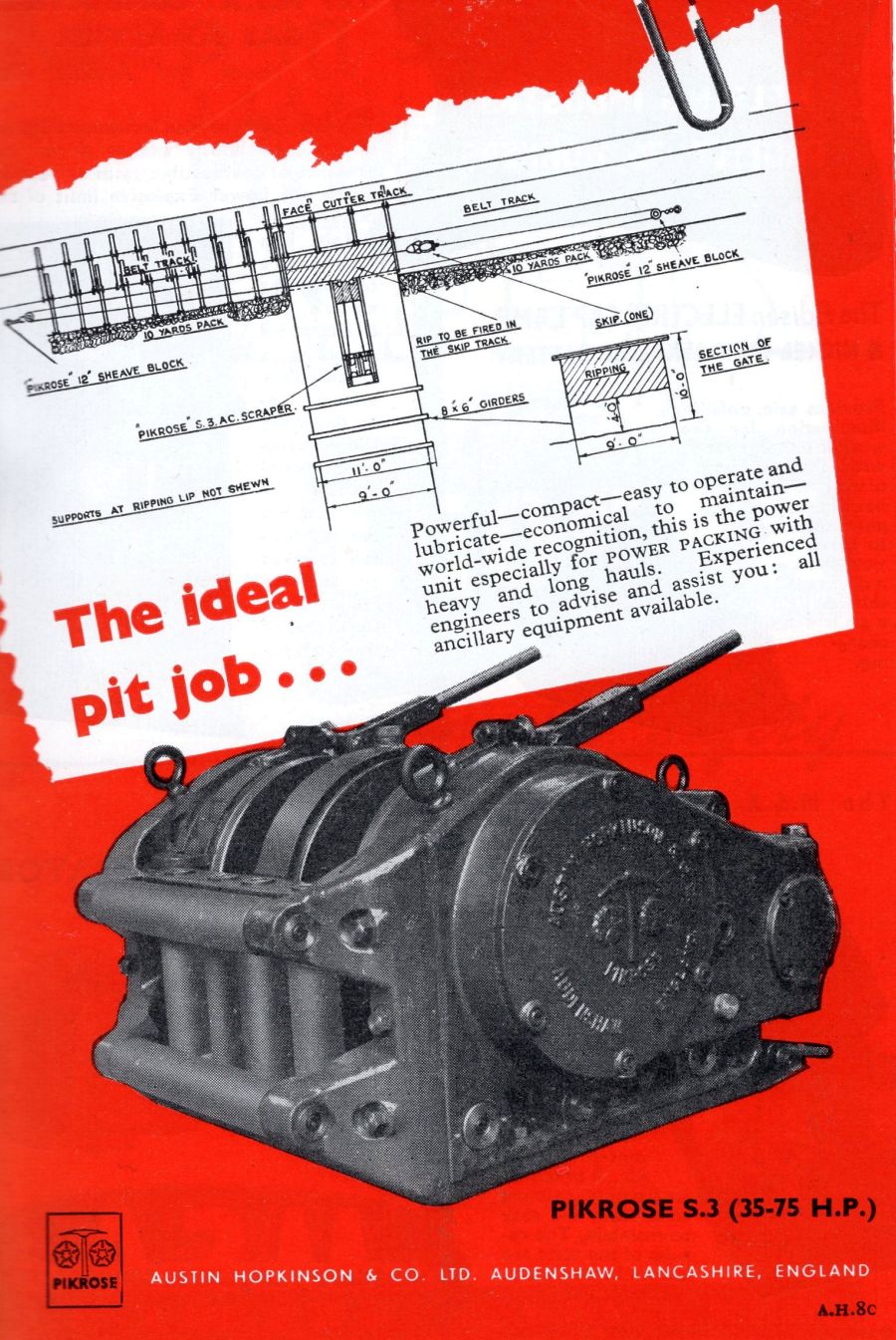
|
|
#6
15-12-2016, 08:04 PM
|
||||
|
||||
|
Not sure what the plan sketch in the pikrose advert is supposed to be? Is it being used to build a pack in the waste/goaf ? I remember something similar, a slusher we called it or 'slusher bucket' operated by something hydraulic about the size of a pikrose. Scooped up stones and rammed them into a pack at the face end.
Anyone know what I'm talking about??
|
|
#8
15-12-2016, 08:33 PM
|
||||
|
||||
|
Anyway. We worked the G seam at Ellington, undersea in the bay, few miles east of Ferneybeds. The workings were constrained by the cover to the sea floor so a shallow seam there too. It had some height about it, so not split like it shows in the sketch of the section in the Ferneybeds shaft.
|
|
#10
16-12-2016, 07:42 AM
|
|||
|
|||
|
Presumably whoever this is has done some homework but in my opinion he can't expect to remove the cap and find all as it was left years ago. I would imagine they will have to start from scratch, also why was it closed in the first place? That area has been opencasted in the past.
|
|
#11
16-12-2016, 11:15 AM
|
||||
|
||||
|
He will have some water to pump out for sure. If the opencast breached any of those old workings he is planning on stopping up then the water flow will never stop? He will have to drain old opencast pits as well?
|
|
#12
16-12-2016, 11:20 AM
|
||||
|
||||
|
I noticed his new intake arterial roadway is a 'loco road'. Locos mean lots of maintenance by fitters and electricians, regular testing etc. Not that small a scale operation then.
When Whittle was privatised did they hang on to the battery locos does anyone know?
|
|
#13
16-12-2016, 04:35 PM
|
|||
|
|||
|
Quote:
|
|
#14
16-12-2016, 05:20 PM
|
||||
|
||||
|
Quote:
This Archaeology report by Durham University for Banks is very interesting. Includes a list of items of archaeological and historical interest, including shipwrecks to WW2 planes. Plus maps of the intended opencast site. It's 60 pages and takes a long time to download: Archaeological Services Durham University for Banks Mining. Highthorn, Widdrington, Northumberland archaeological desk-based assessment
|
|
#15
16-12-2016, 05:40 PM
|
||||
|
||||
|
There you go:
A map showing all the surrounding opencast sites, courtesy Banks Group: http://www.banksgroup.co.uk/wp-conte...OLOGY-PLAN.pdf "There are a number of locations within or adjacent to the study area that have been subject to surface mining in the past, their boundaries are shown on the geology drawing SR03. In chronological order these were: Ferneybeds and North Linton 1943 to 1951 Druridge, 1951 to 1954 Wallis, 1951 to 1954 Chibburn and Radar North, 1952 to 1956 Radar North, 1953 to 1973 Radar South, 1954 to 1962
|
|
#16
16-12-2016, 05:52 PM
|
||||
|
||||
|
On that map there is a tan line showing the perimeter of G2 underground workings.
You can see the area around Ferneybeds colliery marked 'Btm Yard' that was worked by the old colliery. There are other old workings to the east on multiple levels. I assume that is Ellington Colliery.
|
|
#18
17-12-2016, 08:15 PM
|
||||
|
||||
|
Quote:
It's a pleasure. I keep revisiting that map, see more each time. You can see the three outcropping seams Banks are after (+the G seam + ?) and how the shape of the proposed opencast pit is defined by them.
|
|
#19
17-12-2016, 08:44 PM
|
||||
|
||||
|
That 'Diamond' (E2) seam was worked at Ellington with some sort of secondary extraction process they called 'Diamond tops' or 'Diamond topping' This was the removal of a coal roof after the rest of the seam had been extracted by the usual methods.
I can't remember the details, wish I paid more attention now.
|
|
#20
19-12-2016, 09:47 AM
|
|||
|
|||
|
Think back to Whittle Y58 tail gate (the supply road), this Hauler was at the top with an endless rope and lowered the set down on 2 West Winnings and hauled the empties out. Overman Jack Barnfather was in charge on the 0800 day shift (1978- 1983 ish). the brakes were hand operated and if the set came of the way you had to run to the nearest DAC (an electronic voice communication system to the non miners) then inform the operator to stop it by which time it was often a scene of devastation!
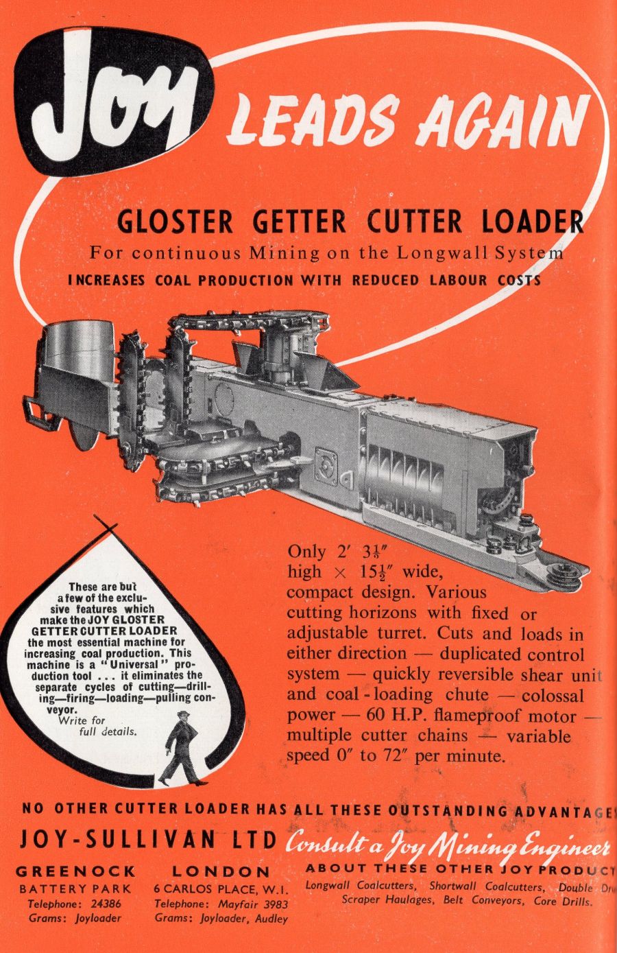
The Gloster Coal Getter looks to an engineers nightmare! 5 cutting jibs means 5 jammed chains, it looks like a pre curser to a shearer. The slusher bucket system didn't prove very popular with the 'bumpers' it often caught in the floor and jammed on the roof knocking out planks and wooden chocks which brought the goaf down in an uncontrolled manner. I think they preferred the 'tripping hammer' method. It couldn't cope with 'rammal' it pushed the stone to the coal side under the belt and it had to be shovelled out. The wire ropes were prone to kinks which made it jump and slew as it went which was very unnerving on a 3ft face with no where to go! 'Rammal' (my spelling is a best guess at a word I have never seen written down) as I understand it was the term used for smaller stone that broke away from the roof, it looked like large gravel, brick sized stones and blue slates, it was very unpredictable and could 'hap you up' with out warning, particularly prevelent Whittle Y23 on the top side.
|
|
|
|


 [perhaps they were from 1954!]


 Linear Mode

