|
|
|
|||||||
| We no longer use activation emails. Please allow 24h after sign up and your account should work |
 |
|
|
Thread Tools | Display Modes |
|
|
|
#1
 20-06-2015, 02:29 PM
|
|||
|
|||
|
Now here's a new one for you all, the Bumping Stone of Warkworth Moor. I was browsing my Northumbrian Magazine, as you do, when I came across a letter from a James H Forster, of Warkworth. He and his father farmed Brotherwick, which includes the Moor, for 60 years and he had no recollection of the Bumping Stone which was mentioned in an article from the previous magazine.
The article by Andrew Curtis included a reference to artificial boundary stones, often named because of their location. One of these was the Bumping Stone on Warkworth Moor. Curtis' response to the letter is: "The Bumping Stone is a substantial stone in a hedge on Warkworth Moor. It marks part of the post 1269 boundary of Sturton Grange, described in a medieval charter........a bumping stone is shown at this point on the first edition Ordnance Survey map of 1866. The name probably derives from the practice of beating the bounds. Although I have never actually seen the stone I have the following information and likely location: "In the hedge next to the path that runs south from the road junction parallel to the railway, east of East House Farm. The stone marked the prominent bend in the parish boundary which here turns east to cross the railway. It marked the corner on the former Warkworth Moor.".........It doesn't feature on any of the later maps." 
|
|
#3
20-06-2015, 05:21 PM
|
||||
|
||||
|
I noticed that odd name on the map the other night. Here's that 1864 map.
I'll see if I can make it semi transparent and lay it over google. (if I can remember how to do that) I've marked the bumping stone in the west, the footbridge and ford. I'm not sure if the latter two actually do line up with the modern equivalents now looking at that. This area was spread across two maps which made it difficult to see what was going on. (merged into one here) 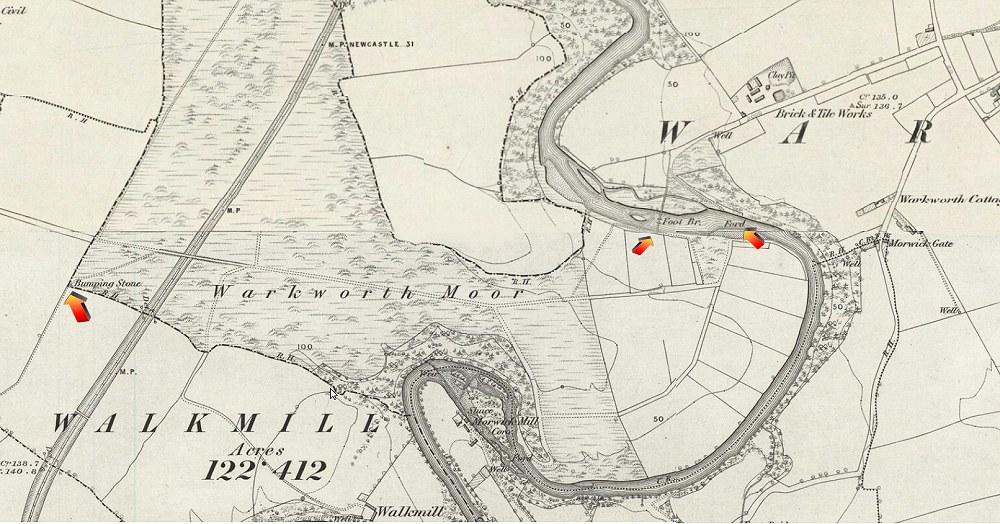
|
|
#7
02-01-2017, 08:54 PM
|
|||
|
|||
|
Where is the 1864 map sourced from? Id be interested in seeing the next section south to see what else was at Morwick at that time.
|
|
#8
02-01-2017, 09:45 PM
|
||||
|
||||
|
Quote:
|
|
#9
02-01-2017, 09:48 PM
|
||||
|
||||
|
Try having a play on this site- Keys to the past, historical maps http://www.keystothepast.info/articl...ils?PRN=N14383
|
|
#10
03-01-2017, 06:44 PM
|
|||
|
|||
|
Thanks very much. Extremely interesting.
|
|
|
|


 Hybrid Mode
